Voyage planning, or passage planning, is a complex operation regulated by the Safety of Life at Sea (SOLAS) convention, the Standards of Training, Certification and Watchkeeping for Seafarers (STCW) convention, and other International Maritime Organization (IMO) guidelines for onboard vessels trading internationally. Voyage planning is a process that helps optimize ship routes, maintain crew safety, and coordinate traffic in and out of busy ports and harbors.
Voyage planning takes an average of 3.5 hours per vessel, according to Maritime Executive. There are many factors to consider during voyage planning, as well as steps required by IMO regulations to ensure each voyage is as safe as possible.
Regulations require shipping companies to complete ship voyage planning in four stages. These are:
First, ship voyage planners — usually the master of the ship and the chief navigating officer — discuss how they plan to get from point A to point B. This includes gathering all information relevant to the passage, evaluating different routes, and pinpointing areas in the voyage where there might be bad weather or other risks. The appraisal stage will consider things such as:
With input from the master of the ship, company guidelines, cargo data, and weather information, the navigating officer will come up with an initial route for the ship to follow.
Next, the Officer of the Watch (OOW) prepares a more detailed plan based on the initial route mapped out in the appraisal process. This detailed plan is laid out from port to port, with areas like wrecks, reefs, shallow water, and emergency stopping points included. This phase will also take into account, among other things:
Contingency planning and aborts — positions in which there is no possible option but to proceed — are especially important to note in this phase. Contingency planning will include alternative routes, safe anchorages, waiting areas, emergency berths.
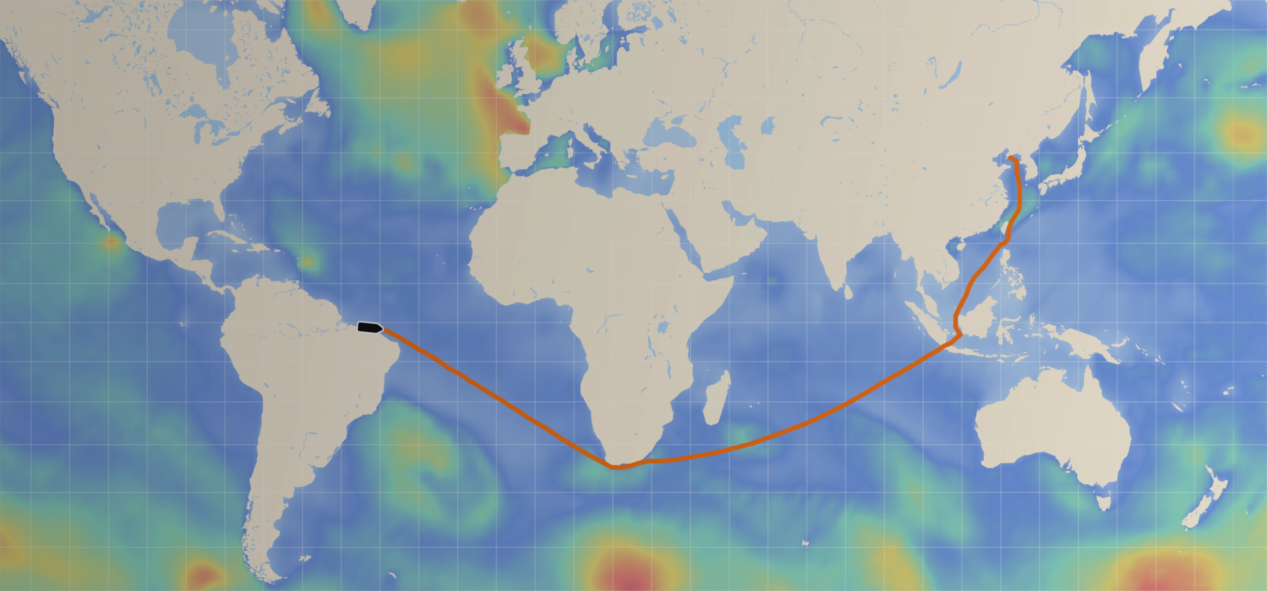
The voyage begins and navigating officers use the plan prepared by the OOW. With Sofar Ocean's Wayfinder, seabound captains can make real-time speed and route adjustments based on changing atmospheric and oceanographic conditions. The routing optimizer evaluates over 100 million routing options based on the latest forecast insight to deliver the safest and most profitable route directly to the ship masters and fleet operations staff.
[Read more: How Maritime Weather Forecasting Minimizes Risks in Shipping Operations]
Wayfinder calculates the path of least resistance across the ocean, ensuring low fuel consumption, on-time arrival, shipshape operations, and crew safety. It determines the optimal speed and route path for any vessel given its dimensions, with capabilities to monitor fleet compliance.
The final required phase of voyage planning is monitoring, checking the position of the ship to ensure it remains a safe distance from danger areas. If the ship’s navigating officer decides that it’s necessary to deviate from the planned route, he or she must inform the master and take precautions to ensure ship and crewmember safety. Good communication is needed during this phase, as well as experience, the right data, and personal judgment.
Voyage planning is a complex, labor-intensive process that requires intense attention to detail. Repetitive manual input can lead to human error: “Multiplied across vessels, companies and fleets, [voyage planning] can show inefficiency, for an industry where optimal resource use and cost savings are now more important than ever,” noted one expert.
Ship voyage planning also needs to account for a number of factors: from shipping deadlines, to weather forecasts, to cargo and crew safety, to fuel costs and route optimization. Some of these priorities can directly conflict, as the safest route may not be the fastest. Vessel parameters, such as ship size, draft, beam, and length also play a role in voyage planning.
Manually planning a ship route introduces weather and climate uncertainties many captains at sea are unwilling to accept. With the impacts of climate change compounding into increasingly extreme conditions, keeping operations on the high seas efficient requires real time ocean data, and lots of it. Wayfinder uses the combined sensing and predictive capabilities of a planetary-scale network of ocean devices to help seafarers make more informed decisions at sea with access to the best weather forecasts.
Wayfinder helps vessel voyage planners optimize safety and savings in one easy-to-use platform. To learn more about Wayfinder, start a Sea Trial.