Imagine a world with no bad weather. No rain, no fog, no storms; all sunshine, all the time. The wind is never blowing, so there are no waves. For the sake of argument, imagine that there are no ocean currents either. In this Beaufort Zero world, navigating across the ocean is easy. The cheapest path between two points is simply the shortest path: the great circle distance.
Unfortunately for all ocean-going vessels, this weatherless world is imaginary. Wind, waves, and currents must all be contended with and accounted for when navigating the globe. These natural complications ensure that the great circle path is almost never the cheapest way to get from point A to point B. For example, slight detours from the great circle might allow a vessel to trade adverse currents for favorable currents, headwinds for tailwinds, or heavy swell for calm seas, resulting in a safer voyage that uses less fuel despite traveling a greater distance.
Of course, the billion dollar question remains: if the great circle is not the cheapest path, then what is? That is precisely the question that Sofar Ocean's Wayfinder helps to answer, and this is the story of how we do it.
We start by collecting vast amounts of ocean data using our global network of free-drifting Spotter buoys. Each Spotter collects wave, wind, current, sea surface temperature, and atmospheric pressure data and transmits it via satellite to our dashboard, providing a real-time snapshot of meteorological conditions and sea state across the most heavily trafficked shipping routes in the world. We then assimilate that data into our proprietary wave model and combine our forecast with global ocean current simulations so that we can predict all relevant metocean variables up to two weeks into the future. With this information, the vessel Captain and Sofar’s operations team can spot potential storms before they pose a threat and plan a route that minimizes danger to the vessel and her crew.
Safe routing is the most important service that Wayfinder offers, but knowing the ocean wave and weather conditions is only one part of the equation. In order to plan a route that is both safe and cost-effective, we also need to know how vessels respond to environmental conditions. That response is captured by our Vessel Performance Model, a high-fidelity and data-driven model that we build for each vessel that we route. Drawing on individual vessel characteristics and historical performance data, the Vessel Performance Model describes how fast a vessel will travel and how much fuel it will burn for a given RPM setting in any combination of wind, wave, and current conditions. This can be visualized using the RPM curves shown in Figures 1-3.
These RPM curves provide helpful intuition into the physics that dictate how vessels respond to environmental conditions, and thus, how we make our routing recommendations. For example, as the current changes from favorable to adverse (from the blue to the red line in Figure 1), the vessel will travel more slowly (Figure 1a) and burn more fuel (Figure 1b) for a given RPM setting. This is akin to paddling upstream in a river: you might expend twice the effort and only go half as fast. Stronger winds and larger waves increase resistance too, as shown in Figure 2, as the Beaufort Force — an estimate of wind speed — increases from a modest BF 2 up to a potentially life-threatening BF 8. However, the extent to which wind and waves impact vessel performance depends strongly on the direction they are coming from. As expected, we see in Figure 3 that head waves and head wind cause the largest decreases in vessel speed and the largest increases in fuel consumption.


Now that we know how much fuel is used and how fast the vessel can travel for a given set of environmental conditions, the final step in the Wayfinder optimization process is to find the cheapest route through safe waters. Safety is ensured by restricting possible paths to regions where forecasted wave heights and wind speed remain below captain-specified thresholds, but measuring economic cost is more complicated. As discussed above, the cheapest route will not necessarily be the route that travels the shortest distance. Rather, the cheapest route will be the one that finds the best combination of fuel savings and time savings.
How do we calculate fuel savings and time savings? We use the Vessel Performance Model! The total fuel cost is quantified as the predicted amount of fuel burned during the voyage multiplied by the current fuel price, whereas the time cost is quantified as the amount of time the voyage takes (route distance divided by predicted vessel speed), multiplied by the opportunity cost of time for that vessel. Therefore, these costs will be lower if the vessel travels faster and burns less fuel, both of which can be accomplished by routing through favorable currents and avoiding strong headwinds or head waves (see Figures 1-3). And while these rules of thumb have been used by captains for millennia, Wayfinder’s state-of-the-art Vessel Performance Model, combined with our highly accurate ocean weather forecasts, ensures that the chosen path is as safe and efficient as possible.
During a voyage, Wayfinder also takes into account additional voyage constraints, such as barred RPM ranges, required time of arrival, and maximum daily fuel allowance. These additional inputs increase the effectiveness of the optimization engine, as the safest, cheapest route can be delivered in the context of a vessel's specific business and safety needs.
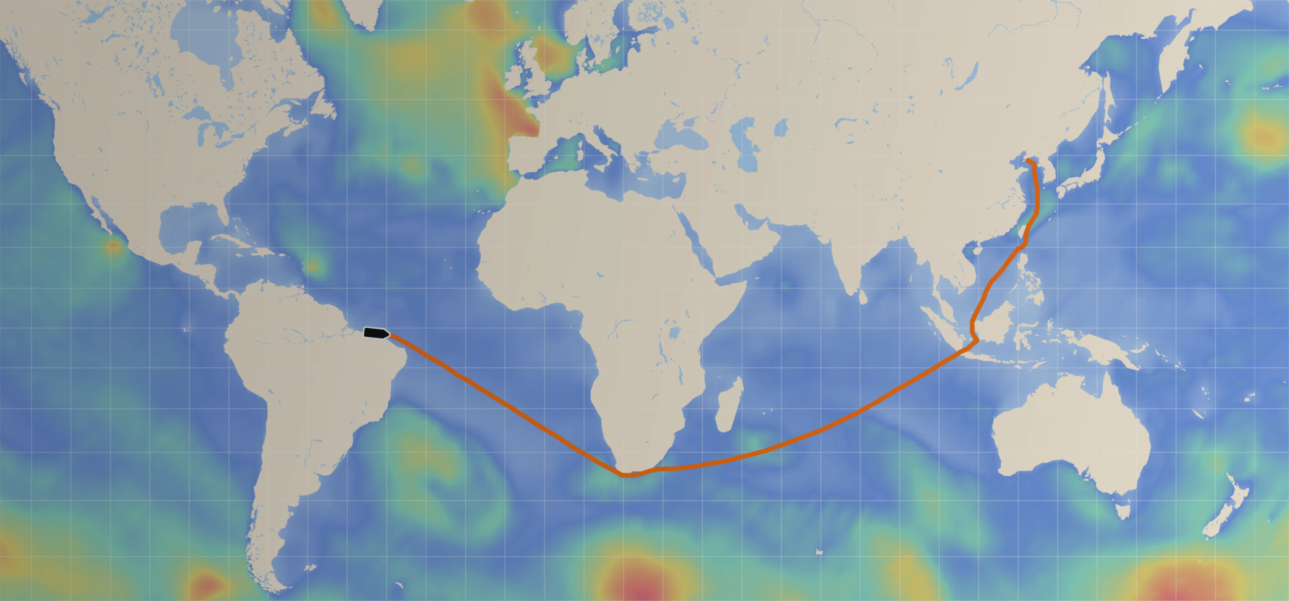
Thus far, this discussion has been purely theoretical, so let’s look at a specific example to clarify how the system works. Figure 4 shows a recent routing scenario where a vessel was steaming from South Africa to Brazil through the South Atlantic. The vessel’s initial route (shown in black) went further south, resulting in a total voyage distance of 3,236 nautical miles. That southern route, however, had a significant drawback: it brought the vessel closer to a major storm system. As shown in Figure 4, the vessel would have encountered 4-5 m bow waves along its initial route, which would not only pose a potential safety hazard, but would reduce the vessel speed and increase fuel consumption, as depicted by the RPM curves in Figure 3.
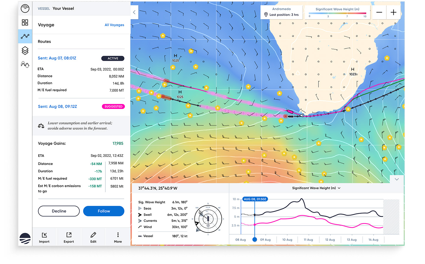
Luckily, this was precisely the type of situation that Wayfinder was created to address. Instead of taking the vessel through the unfavorable weather, Wayfinder found a safer and cheaper route (shown in orange) further to the north. Though this optimized route was 53 nautical miles longer, avoiding the storm’s waves resulted in an arrival time only 26 minutes later than the original ETA. This resulted in a slight reduction in opportunity savings (denoted by the time charter cost), but those losses were vastly offset by the reduced fuel consumption along the optimal route. By avoiding the storm, the vessel was predicted to burn 48 MT less fuel, resulting in a total savings of $13,234 over the course of the voyage.
In an industry like transoceanic shipping with high risk and thin margins, carriers need to capitalize on any opportunity to shave costs. But when harsh weather strikes, the shortest-distance route may not present that opportunity, either because of safety considerations or suboptimal vessel performance. Now, there is a better way: through best-in-class forecast accuracy, tailor-made vessel performance models, and precision guidance, Wayfinder will always find an alternative route that minimizes costs while keeping the vessel, her crew, and cargo safe.