
Across more than 20 peer-reviewed papers, government field reports, and conference proceedings published since 2020, researchers have documented how the Spotter Platform excels in the most demanding ocean environments on Earth. In this blog, we dive into those applications and findings, and examine how Spotter filled critical observational gaps.
Spotter's performance in extreme conditions is built on a foundation of rigorous independent validation.
In a third-party field comparison organized by the U.S. Army Corps of Engineers' Field Research Facility in Duck, North Carolina, Spotter and four other GPS wave buoys were tested over eight months against a Coastal Data Information Program (CDIP)-operated Datawell MarkIII Directional Waverider, one of the most trusted reference instruments in operational oceanography. The paper, published in Coastal Engineering Journal with co-authors from Scripps Institution of Oceanography and the University of Washington Applied Physics Lab, found that Spotter ranked as a top performer across the study with near-benchmark accuracy on significant wave height, the lowest data dropout out of all systems tested, and the best directional spread and mean direction precision.
"We have a good bit of experience deploying and recovering Spotters in the nearshore and over time have put them through their paces,” said lead author Tripp Collins in a plain-language summary of the paper published by Sofar Ocean. “The performance of the Spotter is on par with our most trusted wave measurement systems."
.jpg)
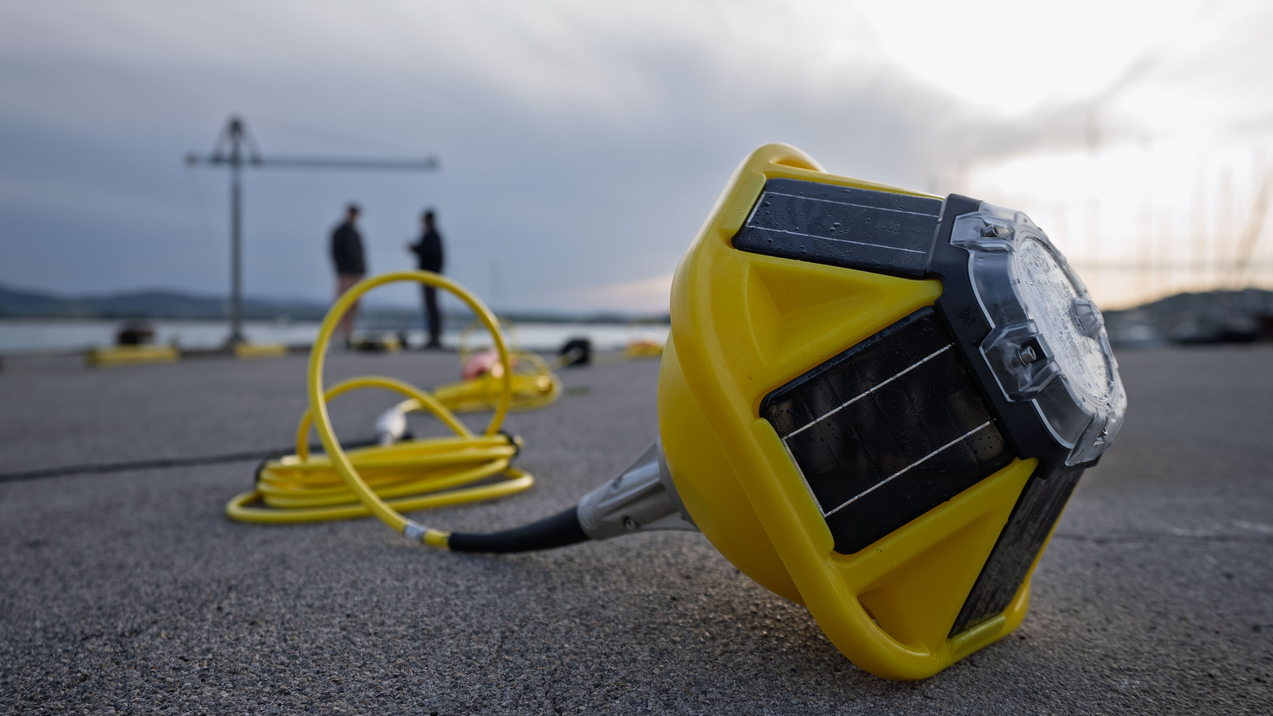
Most Spotter deployments are moored — anchored in one location using conventional mooring or our Smart Mooring, and expected to transmit data in any conditions, testing the platform's durability.
The Great Lakes present a strong test case: winter storms that rival Atlantic coastal events, a freeze-thaw cycle, and a monitoring gap that conventional instruments haven't been able to fill.
During the season when conditions are most extreme, the instruments designed to measure those conditions are typically already onshore. As NOAA scientists noted in a peer-reviewed study on Great Lakes wave forecasting (Geoscientific Model Development, 2024), the standard monitoring buoys "are removed during wintertime to avoid damage to the gauges; therefore, the forecasters qualitatively verified agreement of the model with their observations."
Since 2020, Michigan Technological University and the Great Lakes Observing System (GLOS) have worked to close that gap, deploying Spotter across all five Great Lakes — including at remote, high-exposure sites like Stannard Rock in Lake Superior and Isle Royale that are inaccessible to conventional large-buoy deployments.
In a guest blog for Sofar Ocean, GLOS Communications Specialist David Fitch wrote that placing Spotters in lieu of larger buoys "was a resounding success in terms of continuing to serve regional stakeholder needs." Andrew Barnard, director of Michigan Tech's Great Lakes Research Center, described the practical appeal: "The Sofar Ocean Spotter buoys give us a new tool in monitoring, and reporting to the public, the conditions on the Great Lakes. Their small size, relatively low cost and ease of deployment make them attractive solutions for difficult locations, like at Stannard Rock or at Isle Royale." (Sofar Ocean/GLOS, 2021).
The network has since expanded to Wisconsin's shoreline through a partnership with NOAA's Wisconsin Shipwreck Coast National Marine Sanctuary. Three Spotters are now deployed each season across more than 70 miles of coastline, providing real-time wave, temperature, and wind data to lakefront communities and mariners (NOAA Sanctuaries, 2025).
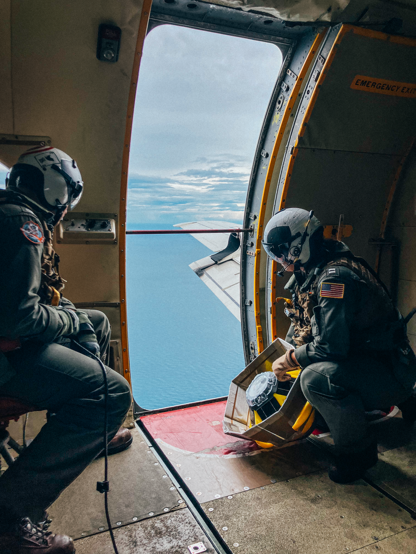
In September 2022, NOAA researchers dropped Spotter into Hurricane Ian through the open door of a NOAA NP-3C aircraft, in free fall, into Category 4 conditions. The resulting measurements, described by Dorsay et al. in OCEANS 2023 (MTS/IEEE Gulf Coast), were subsequently cited as foundational in-situ observations in two later studies: Davis et al. (Geophysical Research Letters, 2023) on wave slope behavior under extreme hurricane forcing, and Davis et al. (Journal of Geophysical Research: Oceans, 2025), which used Spotter observations from inside Hurricane Idalia to investigate wave behavior under sustained winds above 30 m/s.
The same deployment model carried through the 2023 and 2024 Atlantic hurricane seasons, through Sofar Ocean's collaboration with the National Oceanographic Partnership Program's Hurricane Coastal Impacts project. During Hurricane Lee in September 2023, SPOT-1207 passed through the most intense region of the storm and observed significant wave heights up to 12.7 meters, corresponding to individual maximum wave heights of roughly 70 to 80 feet. The following year,, recording significant wave heights of 35.8 feet while simultaneously capturing drops in atmospheric pressure and sea surface temperature caused by the eye passing overhead.
In the western Pacific, two separate Japanese research groups documented similar results from inside extreme typhoons. Kyoto University deployed 44 Spotters into Typhoon NANMADOL in 2022, collecting spectral wave data that were assimilated into a spectral wave model — reducing significant wave height forecast errors by up to 1.2 meters and mean period errors by up to 0.8 seconds, when validated against Japan's coastal wave observation network (Coastal Engineering Journal, 2026). Separately, researchers from Japan's National Research Institute for Earth Science and Disaster Resilience captured observations from inside a 910 hPa Category 5 typhoon — among the most intense central pressures ever recorded in the western Pacific. "We succeeded in making observations that were very close to the eye of the highest-category tropical cyclone," the team wrote, formally acknowledging Sofar Ocean in their paper (Coastal Engineering Journal, 2024).
In summer 2022, U.S. National Ice Center personnel deployed Spotters from the U.S. Coast Guard Cutter Healy on a patrol that reached the North Pole, under a formal Cooperative Research and Development Agreement between Naval Oceanography and Sofar Ocean. "Teaming with industry (Sofar Ocean) allows the collective to attack complex issues of sensing and observing the harshest environment in the world," said USNIC Director, U.S. Navy Commander Casey Gon. The Spotters were selected in part because they are compact, deployable from surface vessels, and designed to withstand harsh conditions at high latitudes. (USNIC press release, 2022)
A 2021 study in Polar Science used Spotters to observe wind waves propagating under grease ice, a viscous early stage of sea ice formation, in the western Arctic Beaufort Sea during conditions when winds exceeded 10 m/s. A 2023 paper in Scientific Data documented Spotter deployments at 82°N in the Laptev Sea and in Antarctic landfast ice breakup near Davis Station, with wave height agreement against co-located instruments within 5%. In Canada's Beaufort Sea, Spotter data collected across multiple open-water seasons from 2014 to 2022 served as the primary observational input for a new Arctic wave forecasting method published in Ocean Modelling (2026).

When researchers trust that an instrument will keep transmitting, they build systems that depend on it.
In the Florida Keys, a team from NOAA's Atlantic Oceanographic and Meteorological Laboratory and the Cooperative Institute for Marine and Atmospheric Sciences deployed Spotter at four Mission: Iconic Reef sites — reefs designated as essential for coral restoration across the Florida Keys National Marine Sanctuary. At the surface, the Spotters measure wave energy, wind speed, sea surface temperature, and pressure; below it, integrated sensors transmit pH and seafloor temperature in near real-time. NOAA noted that collecting and transmitting subsurface data has always been a challenge because current methodologies are often limited by the need for heavy machinery, highly trained personnel, and large vessels — constraints the Spotter-based system was designed to sidestep. Fox Weather covered the deployment in April 2026; a peer-reviewed paper describing the full system, published in HardwareX (2026), reports total data coverage of 91 to 99% of expected hourly measurements across all four sites, and positions Spotter as a cost-effective, modular platform for climate-quality ocean chemistry monitoring.

Brazil's Marine Meteorological Service deployed a Spotter at Copacabana Beach during a high-surf emergency in February 2021, noting that its light weight, low cost, and ease of handling made it well-suited for rapid mobilization and reduced stress on the mooring compared to heavier instrument platforms (Sofar Ocean blog, 2021).
For the Quinault Indian Nation, monitoring the rapidly changing coastline of the Pacific Northwest, Marine Resources Scientist Joe Schumacker put it plainly: "Until now, we have never had a lot of data assets out here on our coast. This information is going to be really critical to mitigate the impacts that occur from extreme weather events." He added: "Spotters give us data, and more data gives us more ability." (Sofar Ocean blog, 2023).
Taken together, these deployments span environments where failure would have been consequential: moored through Great Lakes winters, dropped into Category 4 hurricanes from aircraft, frozen into Arctic sea ice.
In each case, Spotter delivered. The platform offers durability through extreme conditions, delivering robust data and filling critical observational gaps.


.jpg)