So far, we've explored the broader monitoring landscape: the challenges MPA managers face, the tools available and their constraints, the principles that separate effective monitoring from data collection, how the Spotter platform addresses those requirements, and how real teams have put it into practice. The picture is clear. The question now is practical.
How do you design a monitoring strategy for your MPA? Not a generic checklist, but a framework that accounts for your specific objectives, stakeholders, geography, and budget. This chapter walks through the questions every monitoring strategy needs to answer.
What decisions does your monitoring need to support?
Too many monitoring programs begin with the question “what should we buy?” The better starting point is “what decisions will this data need to support?” Technology is a means. The objective is the decision it enables.
Different management objectives lead to fundamentally different monitoring designs. An MPA focused on enforcement needs near-real-time vessel detection and evidence that holds up in court. An MPA tracking coral reef recovery needs long-term temperature baselines, dissolved oxygen trends, and periodic species surveys. Clarifying objectives first prevents the common trap of collecting data that is interesting but not connected to any management action.
Common monitoring objectives for MPA managers
Enforcement and compliance
Detecting unauthorized activity, documenting violations, providing evidence for prosecution.
Ecological baselines
Tracking habitat condition, species composition, and water quality trends over months and years.
Climate adaptation
Monitoring thermal stress, ocean acidification, sea level changes, and storm exposure.
Stakeholder reporting
Generating evidence of conservation impact for funders, government agencies, and local communities.
Restoration validation
Measuring whether interventions like coral outplanting or fishing closures are producing intended outcomes.
The five principles from previous chapters provide a useful evaluation lens once objectives are set. A strategy focused on enforcement will weight real-time data delivery heavily. A strategy focused on ecological baselines will prioritize continuity and evidence grade. Most MPA managers will find their programs need to serve multiple objectives simultaneously, which makes this initial clarity even more important.
Who needs the data, and in what form?
An MPA manager rarely works alone. The data from a monitoring program flows to multiple audiences, and each one needs it delivered differently. A strategy that serves one audience well while ignoring the others will create friction that undermines the entire effort.
A monitoring strategy is also a communication strategy. The same data, packaged for the right audience at the right time, can satisfy a funder, inform a ranger, and support a prosecution.
Mapping stakeholder requirements early reveals where data formats can be standardized, where reporting cadences align, and where additional processing is needed. It also exposes the common failure mode: a program that collects excellent data but delivers it in a form only one stakeholder can use.

Effective monitoring strategy requires coordinating the needs of multiple stakeholders from the start.
What do you already have?
Most MPAs are not starting from zero. Before planning new deployments, take stock of what already exists. Satellite imagery from the Copernicus Sentinel program provides free global ocean coverage (Sentinel-3 for sea surface temperature and ocean color, Sentinel-1 for SAR-based maritime monitoring), while Landsat, also freely available since 2008, covers coastal zones relevant to nearshore MPAs. Historical field surveys, even if irregular, provide baseline data. Partner organizations at local universities or NGOs may have datasets they would share. Existing instruments may still be in the water, in storage, or available through equipment-sharing agreements.
The institutional knowledge of rangers, boat captains, and field technicians is an asset too. They often know things no instrument has recorded: where illegal fishing concentrates, which reef patches show stress first, how seasonal weather affects access. For each tool you already have, ask what it covers well and where the gaps are. The gap analysis matters more than the equipment list.
The gap analysis question
For each monitoring objective you identified in Question 1, ask: can my current data sources support a timely, evidence-grade decision? Where the answer is no, that is where new investment will have the highest impact.
What sensing approach fits your objectives?
With objectives defined and gaps identified, the question becomes practical: what system configurations will address your specific monitoring needs? This is where design decisions get concrete. An MPA focused on coral bleaching early warning needs continuous subsurface temperature profiles at reef depth. A program tracking water quality needs dissolved oxygen, pH, and turbidity sensors. Acoustic vessel surveillance requires hydrophones positioned along likely intrusion routes.
The Spotter platform's modular architecture, built on the Bristlemouth open standard, is designed for exactly this kind of objective-driven configuration. Managers select sensors matched to their priorities and swap them as needs evolve, without replacing the platform itself.
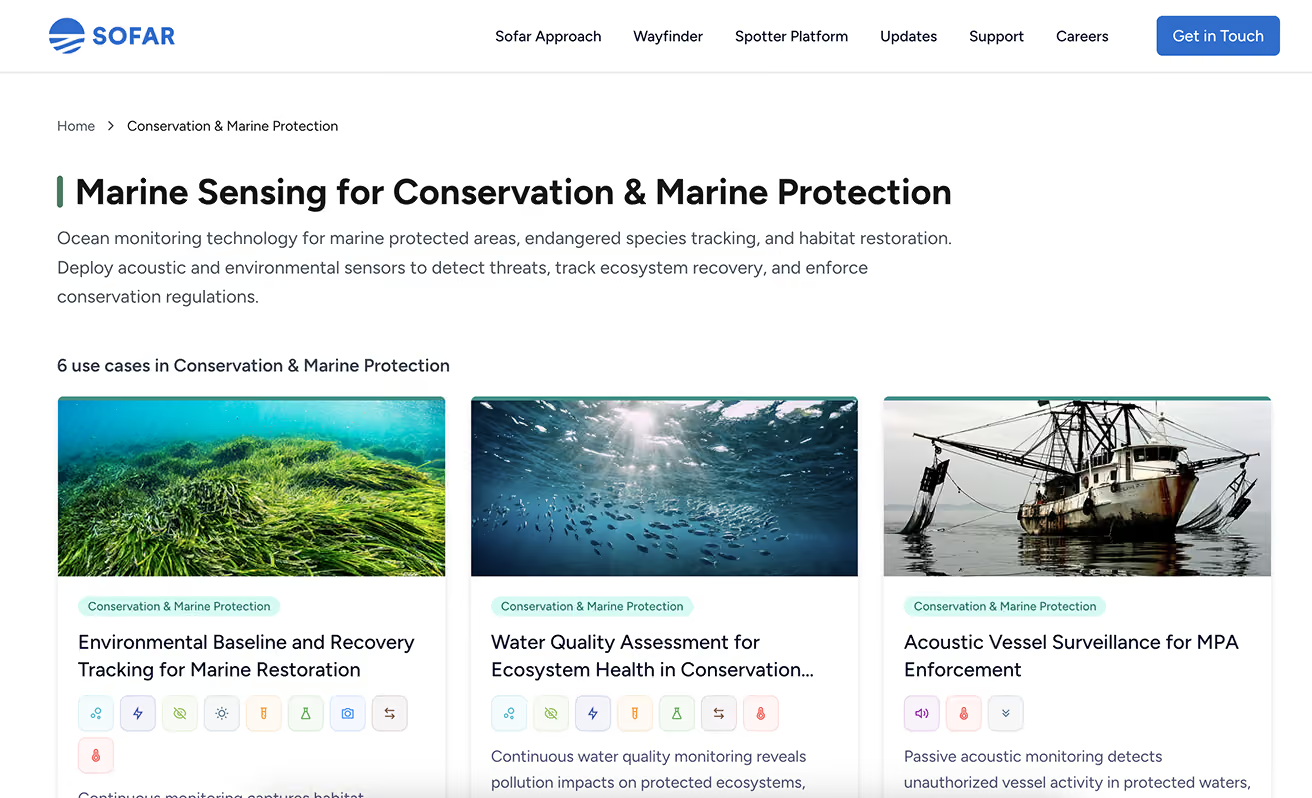
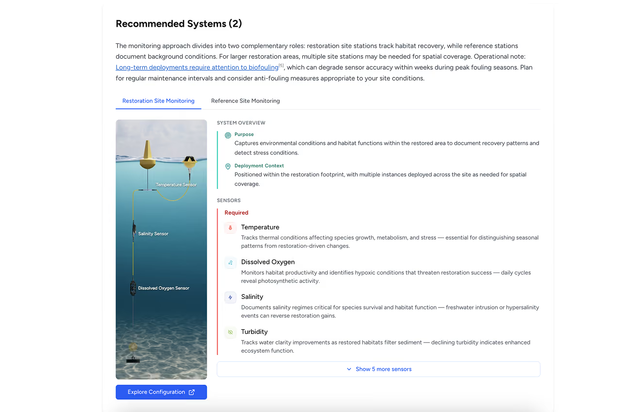
Sofar Ocean's Marine Sensing Use Case Library provides a practical starting point. It maps common conservation monitoring objectives to recommended system configurations, with sensors organized by priority: required, important, and nice-to-have for each use case. Whether the goal is coral bleaching early warning, environmental baseline tracking, water quality assessment, or acoustic vessel surveillance, the library shows what a purpose-built monitoring system looks like.
Explore the Use Case Library
Browse conservation monitoring use cases with recommended sensor configurations, deployment contexts, and system overviews tailored to specific MPA management objectives.
Where do you need coverage, and how much?
Where you place monitoring matters as much as what you measure. A single high-capability station at one location leaves the rest of the MPA unobserved. Spatial design is the difference between a demonstration project and operational coverage.
Start by identifying priority sites: critical habitats under the most pressure, boundaries where unauthorized activity concentrates, gradient locations that capture how conditions change across the protected area. Coral reef managers often need measurements at both shallow reef crests (where thermal stress hits first) and deeper refugia (where species may retreat). Enforcement-focused programs need coverage along likely intrusion corridors, not just at the center of the protected zone.
Florida Keys deployed seven Spotters at its Mission: Iconic Reefs sites to provide real-time, reef-scale oceanographic data, addressing a well-documented limitation of satellite SST, which can miss localized thermal amplification on shallow reefs by up to several degrees. South Africa is building a national network because conditions vary dramatically along their coast.
Conditions at one end of a reef can be dramatically different from those at the other. A single monitoring device will always leave critical gaps.
Platforms like Spotter change the cost equation for distributed deployment. When coverage becomes a design choice rather than a budget constraint, the question shifts from “can we afford more than one station?” to “where will additional stations add the most value?”
How does data get from the sensor to a decision?
Collecting data is only half the problem. Getting it to the right person in the right format fast enough to matter is the other half. Previously we drew the line between actionable and archival monitoring. The distinction comes down to the data pipeline: the path from sensor reading to human decision.
A well-designed pipeline answers several practical questions. Who receives alerts when conditions cross critical thresholds? How quickly does data need to arrive for the response to be meaningful? Can the system integrate with existing tools, whether a GIS platform, a national reporting database, or a simple email alert? The Spotter Dashboard and API handle this by delivering data from every device in a network to a single interface with configurable alerts, historical access, and API endpoints for programmatic integration. No retrieval mission, no manual download, no format reconciliation.
The pipeline test
For each monitoring objective, trace the path from sensor to decision-maker. If there is a step that requires a boat trip, a manual download, a file format conversion, or a wait of more than a few hours, that step is where the pipeline will break under real operating conditions.
How will you fund it sustainably?
Earlier, we introduced the structural challenge: permanent conservation mandates funded by temporary money. A monitoring strategy that depends on a single funding source is a monitoring strategy with an expiration date.
The strongest funding case is built on evidence. Monitoring generates data. Data demonstrates conservation impact. Impact evidence justifies continued or expanded investment. This is the positive version of the reinforcing cycle: better monitoring produces stronger evidence, which attracts more sustained support.
The best time to plan your funding narrative is before you deploy your first sensor. The data you collect should be designed to tell the story your next funder needs to hear.
Phased deployment is a powerful de-risking strategy. Starting small, with a limited deployment at one or two priority sites, reduces upfront costs and generates early evidence of value. That evidence becomes the foundation for the next funding request. Funders are more willing to invest in expanding a program that has already demonstrated results than in building an unproven system from scratch.
How do you start, and how do you grow?
Do not try to build the final state on day one. Deploy at your highest-priority site, the location where better data would make the biggest difference to a specific management decision. Learn what works and what needs adjustment. Demonstrate value to your stakeholders with real evidence from a real location. Then expand.
Building institutional capacity alongside infrastructure is essential. Train local staff on equipment maintenance and data interpretation. Document protocols so the program does not depend on a single person. Plan maintenance schedules before deployment, not after. A monitoring network is not a project with an end date. It is an operational capability that requires sustained attention, and designing for that reality from the beginning is what separates programs that last from programs that go quiet.
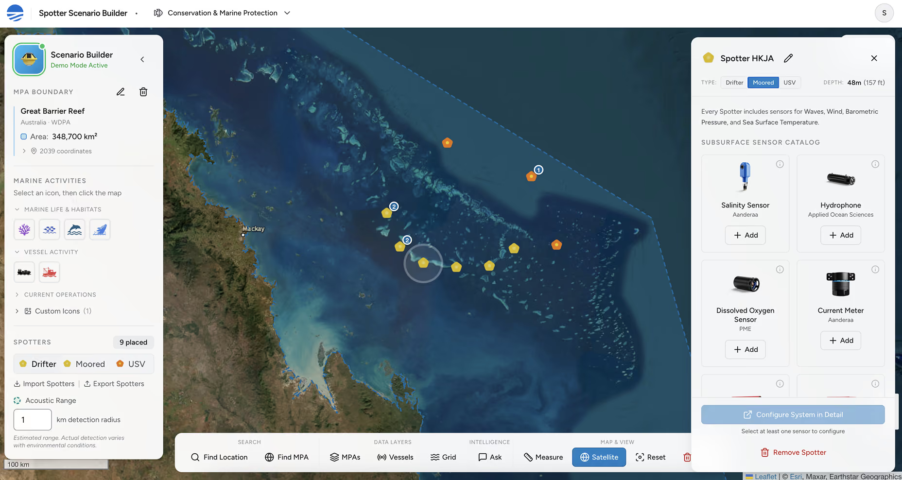
The Spotter Scenario Builder: map your MPA, place monitoring systems, add sensors, and model a deployment before committing resources.
Model your deployment
The Spotter Scenario Builder is designed to help MPA managers take the next step. Define your MPA boundary, map the habitats and activities you need to monitor, and place Spotter systems across your area. The tool lets you add sensors to each Spotter system, model coverage, and save and share your plans with colleagues and funders.
Marine protected areas work when they are managed with evidence, not assumptions. The gap between designation and real protection has always been an operational gap: too little data, arriving too late, reaching too few decision-makers.1–3 That gap is closing.
The tools exist. The cost barriers that once limited monitoring to well-funded sites are falling. The frameworks for making monitoring actionable, integrated, and evidence-grade are well understood. What remains is the decision to start.
This guide was built for the people at the center of that work. The MPA managers, researchers, government officials, and funders who are trying to make ocean protection actually deliver results. The questions in this chapter are your starting framework. The tools are ready. The ocean is not waiting.
1. Edgar, G.J., Stuart-Smith, R.D., Willis, T.J., et al. (2014). Global conservation outcomes depend on marine protected areas with five key features. Nature, 506(7487), 216–220. doi: 10.1038/nature13022
2. Gill, D.A., Mascia, M.B., Ahmadia, G.N., et al. (2017). Capacity shortfalls hinder the performance of marine protected areas globally. Nature, 543(7647), 665–669. doi: 10.1038/nature21708
3. Grorud-Colvert, K., Sullivan-Stack, J., Roberts, C., et al. (2021). The MPA Guide: A framework to achieve global goals for the ocean. Science, 373(6560), eabf0861. doi: 10.1126/science.abf0861